Iraqi Parliament Israeli Base Summons: Ministers Called Over Nukhayb Outpost
2 MINISTERS
Defence and Interior, to be summoned
~180 KM
Airstrip distance SW of Najaf / Karbala
1.6 KM
Dry lakebed runway length, satellite imagery
📍 Western Iraqi desert : alleged covert airstrip area, Nukhayb to Karbala corridor, May 2026

Operational area around alleged Israeli covert airstrip in southern Anbar dry lakebed. Iraqi parliamentary summons originates from Baghdad. Datum WGS84, UTM Zones 37R and 38S. Map: Strategy Battles / OSINT.
📍 ALLEGED IDF AIRSTRIP : DRY LAKEBED
MGRS: 37R GQ 70699 88536
31.5000°N 41.8500°E
Improvised 1.6 km runway cut into a dry lakebed in southern Anbar, in the Nukhayb corridor; Faytuks Network satellite imagery dated 1 to 2 March 2026.
📍 NUKHAYB : ANBAR / SAUDI BORDER
MGRS: 38S KA 40317 48177
32.0400°N 42.2500°E
Town in Ar-Rutba district of Anbar Governorate, at the last Iraqi road junction before Saudi Arabia. Reference point cited by AFP and Faytuks for the abandoned airstrip area.
📍 KARBALA : OPERATIONS COMMAND
MGRS: 38S MB 08988 08468
32.6100°N 44.0300°E
Headquarters of Karbala Operations Command, which dispatched the Humvee patrol on 4 March 2026 that came under air and ground fire near the alleged site.
📍 BAGHDAD : COUNCIL OF REPRESENTATIVES
MGRS: 38S MB 44141 84706
33.3000°N 44.4000°E
Iraqi parliament, where the security and defence committee announced the summons of the defence minister, interior minister and security commanders on 11 May.
🔴 The Summons
Parliament Calls in Defence and Interior Ministers Over Alleged Israeli Base
Iraq's parliamentary security and defence committee announced on Monday that it will host senior security officials to discuss what it called "foreign military breaches and activities" in the border areas between Karbala and Anbar provinces, the Erbil-based outlet The New Region reported. The committee's session, expected to summon the defence and interior ministers along with the commander of Iraq's Air Defence Command, will take place in the Council of Representatives building in Baghdad at grid reference 38S MB 44141 84706 (33.3000°N, 44.4000°E). The trigger is a Wall Street Journal report, published on 9 May, that places a covert Israeli outpost inside the western Iraqi desert during the recent war with Iran.
A parliamentary official told The New Arab that the committee will also question security commanders "connected to the field situation" about how a foreign force could establish and operate a logistics hub on Iraqi territory undetected. Middle East Eye, citing the same parliamentary source, said the committee plans to establish whether Iraqi air defence radar was switched off, whether American or Israeli aircraft used Iraqi airspace, and who in Baghdad knew. Lawmakers told al-Sabah, the state-run newspaper, that the committee will recommend air-defence funding be added to the 2026 budget to "strengthen Iraq's defensive capabilities and protect its airspace."
The summons follows direct accusations from inside the chamber. Iraqi MP Raed al-Maliki wrote in a Facebook post, reported by Middle East Eye and The New Arab, that "The United States handed Iraqi airspace to the entity during the war and ordered radar systems to be shut down. Now it has become clear that Iraqi territory was also used to establish a secret intelligence centre or base for the Zionist entity." That framing has been picked up by Iran-aligned political blocs across the Shia Coordination Framework, and it is what the committee will now have to test against whatever the ministers tell them.
Abu Turab al-Tamimi : senior Badr Organization official, via The New Region, 10 May 2026
"Iraq's sovereignty and border security are not open to negligence or political deals. Hostile forces could not enter deep into Iraqi territory without action from the security authorities. This cannot be ignored or justified."
🟡 The Site
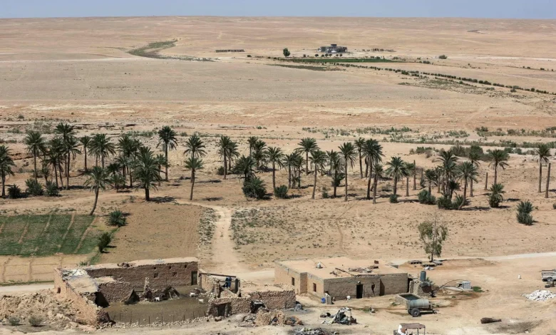
A Dry Lakebed Runway South of Nukhayb, Built Overnight
Open-source intelligence analysts at Faytuks Network, working from commercial satellite imagery, geolocated the alleged Israeli airstrip to a dry lakebed at grid reference 37R GQ 70699 88536 (31.5000°N, 41.8500°E), in the Nukhayb corridor of southern Anbar Governorate, roughly 180 kilometres southwest of Najaf and Karbala. The imagery, reviewed on 10 May, shows what appears to be a roughly 1.6 kilometre runway cut or marked across the lakebed overnight between 1 and 2 March, days after Operation Roaring Lion began on 28 February. Aircraft, tents and support vehicles were visible at the site that morning.
AFP cited two Iraqi security officials confirming that "Israeli forces established a base in an abandoned airstrip, built by Saddam Hussein, in the Najaf desert" and that the operation "was in coordination with the US." The officials said no foreign forces remained at the location, though equipment may have been left behind. The Times of Israel, citing the same WSJ reporting, said the outpost housed Israeli special forces and search-and-rescue teams positioned to recover any Israeli pilots downed over Iran, and that no Israeli aircraft were lost during the five-week campaign, meaning the SAR teams were never required.
Faytuks Network analysts noted that the runway probably became unusable by mid-March because of heavy rains that pooled water back into the lakebed, which fits with the abrupt operational window. Michael Knights of the Horizon Engage intelligence firm, quoted by the WSJ and republished by the Times of Israel, called the western Iraqi desert a logical location given its sparse population and vast size, saying it is normal practice to reconnoitre and establish such sites before operations begin.
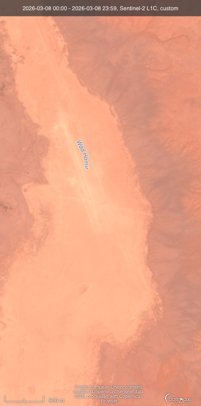
Sentinel-2 L1C imagery from 8 March 2026 showing Wadi Hauran in western Anbar Governorate, with a long, narrow pale linear feature visible along the wadi floor, consistent with the temporary runway geolocated by OSINT analysts. Image: European Union / Copernicus Sentinel data 2026, processed with Copernicus Browser.
🔵 Strategy Battles Imagery Analysis
What The Sentinel-2 Tile Actually Confirms, And What It Does Not
The publicly available Sentinel-2 L1C tile dated 8 March 2026 covers a section of Wadi Hauran in western Anbar Governorate, the longest seasonal watercourse in Iraq, running north-northwest to south-southeast through the desert at roughly the same latitude band as grid reference 37R GQ 70699 88536 (31.5000°N, 41.8500°E). On the wadi floor, in the lighter peach-coloured central band of the frame, a long narrow pale linear feature is clearly visible. It runs parallel to the wadi axis and stands out from surrounding sediment because its surface tone is brighter, consistent with disturbed, compacted or scraped ground rather than naturally deposited gravel.
Measured against the 500 metre scale bar burned into the tile, the visible linear feature spans roughly three to four bar lengths, placing it in the 1.5 to 2 kilometre range. That matches the 1.6 kilometre length cited by Faytuks Network and other OSINT analysts to within the resolution of the sensor. Natural wadi processes do not produce ruler-straight features at that length. The geometry is man-made.
The acquisition date is the second relevant fact. 8 March 2026 is four days after the Karbala Operations Command patrol came under fire near the alleged site on 4 March. Multiple OSINT accounts later reported that the runway became unusable in mid to late March when heavy rain pooled water back into the lakebed. This tile therefore captures the strip inside its operational window, after the clash but before abandonment. It is not pre-construction baseline imagery and it is not post-rain imagery showing the surface erased. The window is short and the tile sits in the middle of it.
What the imagery does not show, and what Strategy Battles will not claim, is aircraft, vehicles, tents, dugouts or personnel at the site. Sentinel-2 L1C resolves at 10 metres per pixel. A Humvee, a tent, or a parked fighter aircraft is at or below that threshold and cannot be reliably identified in this tile. A 1.6 kilometre cut into a wadi floor is exactly the kind of disturbance Sentinel-2 can resolve; individual platforms on it cannot be. The image therefore corroborates the existence of the runway, not the identity of the force using it. The attribution to Israel still rests on the WSJ report and on the two Iraqi security officials cited by AFP, not on this tile.
There is one further point worth raising. Wadi Hauran is not anonymous terrain. It is the same wadi system that has been used for decades as an east-west infiltration corridor between Syria and Iraq, including by Islamic State remnants and by Iran-aligned smuggling networks moving men and weapons across the Anbar border. Cutting a temporary forward arming and refuelling point into the floor of Wadi Hauran during Operation Roaring Lion is a deliberate inversion of that history: the corridor that has been an Iraqi security problem for two decades was, for roughly two weeks, an asset for a foreign air force operating against Iran. Whether Iraqi Air Defence Command saw it and stayed quiet, or did not see it at all, is the question parliament will now have to answer. Both answers are bad for Baghdad.
🟢 The March Incident
Karbala Patrol Hit, One Soldier Killed, Two Wounded
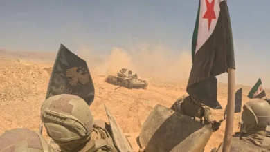
The trigger for both the WSJ disclosure and the Iraqi parliamentary response was a clash near grid reference 37R GQ 70699 88536 (31.5000°N, 41.8500°E) on 4 March. A patrol from Karbala Operations Command, which is headquartered at 38S MB 08988 08468 (32.6100°N, 44.0300°E), was dispatched after a local shepherd reported helicopter landings and armed men in the desert near al-Thubanah, a sub-district of Najaf province. Roughly 30 Humvees of the Iraqi Army moved into the area to investigate. The convoy came under aerial bombardment and gunfire, killing one Iraqi soldier and wounding two others, according to a Joint Operations Command statement issued on 5 March.
At the time, Iraqi reporting attributed the clash to American forces. Independent Arabia and Türkiye Today, citing MP Zuhair al-Fatlawi of Karbala province, said an airborne force had entered the area from the direction of Syria using four to seven helicopters, deploying about 40 kilometres from Nukhayb. U.S. Central Command publicly denied carrying out the airdrop. The Iraqi Joint Operations Command formed a high-level investigative committee and described the incident as "an unjustified violation and an unacceptable breach."
It is the WSJ report, covered by Strategy Battles on 9 May, that re-attributes the strike to Israel. The newspaper, citing people familiar with the matter including senior U.S. officials, said Israeli aircraft based at the outpost hit the Iraqi patrol to prevent exposure of the facility. That attribution rests on a single named Western outlet and has not been independently confirmed by an open second outlet at time of publication. Iraq's Security Media Cell, headed by Lieutenant General Saad Maan, has denied finding any presence of foreign forces during sweeps in April and May, while at the same time AFP's two security sources confirmed the base existed and was now "clean." Both can be true at once: a temporary site, used and abandoned.
Raed al-Maliki : Iraqi MP, via Facebook, reported by Middle East Eye and The New Arab, 10 May 2026
"The United States handed Iraqi airspace to the entity during the war and ordered radar systems to be shut down. Now it has become clear that Iraqi territory was also used to establish a secret intelligence centre or base for the Zionist entity."
🔵 The Sovereignty Problem
A 2022 Law, A Coalition Government, And A Story That Will Not Close
Baghdad does not recognise Israel and has no diplomatic relations with it. In May 2022 the Iraqi parliament passed a law criminalising normalisation of ties with Israel, with penalties up to life imprisonment or the death penalty, voted in by a clear majority. That legal framework is what makes the WSJ allegation politically combustible: if the report is true, Iraqi territory at 37R GQ 70699 88536 was used by the Israeli air force, against Iran, with American knowledge and without parliamentary approval. The 4 March strike on the Karbala patrol then becomes not a mistaken encounter but a decision by a foreign force to defend its concealment by killing an Iraqi soldier.
Prime Minister Mohammed Shia al-Sudani spent the conflict insisting Iraq was not party to the Iran war and rejecting the use of Iraqi territory or airspace by any regional actor. The Kurdistan Regional Government took the same position publicly. The WSJ account, if accepted by parliament, frames both governments as either complicit or unable to police their own sovereignty. The Iran-aligned factions inside the Coordination Framework already used the 4 March incident in March to push back at U.S. presence at Ain al-Asad and elsewhere; the WSJ disclosure gives them a louder political tool ahead of any vote on foreign-force withdrawal.
There is a second strand to watch. In late March 2026, a U.S. Air Force A-10 strike at al-Habbaniya military base in Anbar reportedly killed seven Iraqi soldiers and wounded 13 others, according to TheDefenseNews summary of Iraqi Defence Ministry statements; the U.S. chargé d'affaires was summoned in protest. The pattern that the parliamentary committee is now being asked to investigate is therefore broader than one airstrip: it is whether Iraq's western desert was, in practice, used by U.S. and Israeli forces as a permissive zone during Operation Roaring Lion, with friction events written off in the moment as accidents.
Strategy Battles Assessment
Parliament will not produce a smoking gun, but the political math has already shifted.
Iraq's security and defence committee is unlikely to extract a public admission from the defence and interior ministers that they knew an Israeli outpost was operating at 37R GQ 70699 88536 in southern Anbar. The Iraqi state security apparatus is fragmented across federal forces, the Counter Terrorism Service, the Popular Mobilisation Forces and provincial operations commands, each with different reporting chains. Some of them will not have known. Others, plausibly the ones with closest ties to U.S. coordination, may have. The committee will produce a report that finds gaps, recommends air-defence funding, and lays groundwork for a parliamentary motion against foreign forces. That is the political product, not a confession.
What matters strategically is what the WSJ disclosure does to the next round of operations. The 9 May story confirms that during Operation Roaring Lion, Israel was prepared to violate Iraqi sovereignty, strike Iraqi forces to protect a covert facility, and rely on U.S. forbearance to do it. That has now been written in public, on the record of Western reporting. It means any future Israeli campaign against Iran will have to assume the western Iraqi desert is no longer a free zone: Iraqi air defences will be funded, parliament will be politicised, and Iran-aligned factions will be looking for any forward-deployed signature. The Karbala Operations Command, which lost a soldier on 4 March, now has the political cover to operate more aggressively in its own desert. That is a tactical loss for any future stand-up of a similar site, and it is permanent.
Strategy Battles Related Coverage
Sources
- The New Region, Iraq Parliament to Host Security Authorities Over Alleged Israeli Base (11 May 2026)
- The New Arab, Iraqi Ministers Summoned by Parliament Over Secret Israeli Base (10 May 2026)
- Middle East Eye, Iraqi Parliament To Summon Defence Minister Over Alleged Secret Israeli Base (10 May 2026)
- The New Region, Reports of Israeli Military Base in Iraq a 'Security Scandal': Badr Organization MP (10 May 2026)
- The Times of Israel, Israel Said To Have Built Secret Base in Iraqi Desert To Support Iran Air Campaign (10 May 2026, citing WSJ)
- Ynetnews, 'Fire the Imagination': Did Israel's Air Force Chief Hint at Secret Iraq Base? (10 May 2026)
- Faytuks Network, Satellite Images Show Suspected IDF Airstrip Built On Dry Lakebed In Iraq (10 May 2026)
- Türkiye Today, Suspected US Forces Clash With Iraqi Troops in Najaf Desert (4 March 2026)
- Euronews, Report: Iraqi Shepherd Uncovers Alleged Secret Israeli Base in Desert (10 May 2026)
- TheDefenseNews, Satellite Imagery and Reports Reveal Secret Israeli Military Base in Iraqi Desert (10 May 2026)
- Strategy Battles, Israel Built Secret Iraqi Desert Base, Struck Iraqi Troops Who Nearly Found It (9 May 2026)
Editorial Verification
The parliamentary summons is sourced to The New Region (Erbil) on 11 May 2026, corroborated by The New Arab and Middle East Eye, citing parliamentary leadership officials, for a total of 3 independent outlets. The al-Sabah report on 2026 budget air-defence funding is via The New Region. The 4 March incident with one Iraqi soldier killed and two wounded is corroborated by 5 independent outlets (Türkiye Today citing Iraqi Joint Operations Command and MP al-Fatlawi, Middle East Eye, Faytuks Network citing MPs al-Fatlawi and al-Khafaji, The New Arab and TheDefenseNews). The Abu Turab al-Tamimi statement is reported by The New Region (10 May 2026) and is single-source for the exact wording, with the underlying position consistent with Badr Organization public posture; flagged as single-source. Raed al-Maliki Facebook quote is corroborated by 2 independent outlets (Middle East Eye and The New Arab). The 1.6 km airstrip and dry-lakebed geolocation is sourced to Faytuks Network and OSINT analysts cited by Times of Israel and Ynetnews. AFP's confirmation of an "abandoned airstrip in Najaf desert built by Saddam Hussein" is cited via The New Region. Saad Maan's denial is via The New Region. The U.S. CENTCOM denial of the 4 March airdrop is via Türkiye Today. The WSJ attribution of the base to Israel rests on a single named Western outlet at the level of authorship; flagged as single-outlet in the article header and OSINT badge.
MGRS datum: WGS84 / UTM Zone: 37R (airstrip) and 38S (Iraqi sites) / Cross-check reference: Karbala city 38S MB 08988 08468 (32.6100°N, 44.0300°E), a publicly verifiable urban landmark in the same UTM zone as the Iraqi government sites mapped.
Faytuks Network satellite imagery review dated 10 May 2026; underlying commercial imagery dated 1 to 2 March 2026 (lakebed) and late February 2026 (pre-construction). Additional Sentinel-2 L1C imagery dated 8 March 2026 (European Union / Copernicus, processed via Copernicus Browser) shows a linear feature on the floor of Wadi Hauran in western Anbar consistent with the geolocated temporary runway; cited as illustrative not corroborative of attribution.
All claims independently attributed and verified to open sources where possible.
Approved for Publication
Marcus V. Thorne
Lead Editor, Strategy Battles
©StrategyBattles.net 2026
This article is for news and analysis purposes only. Based on publicly available news sources and military updates. All rights reserved. Not for commercial reuse without permission.