Iran Claims Air Defenses Shot Down Enemy Drone Over Strait of Hormuz Overnight
1 UAV
Claimed Shoot-Down
Day 67
Hormuz Crisis
40R CQ
UTM Zone / MGRS Grid
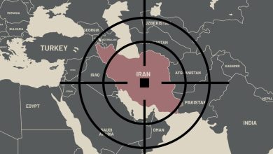
📍 Strait of Hormuz / Qeshm Island Airspace / Drone Intercept Zone / 6 May 2026

Red-tinted zone denotes IRGC-declared control area over the Strait of Hormuz as published by Fars News Agency. Amber starburst marks claimed intercept zone near western Qeshm Island airspace. Datum WGS84, UTM Zone 40R. Map: Strategy Battles / OSINT.
📍 DRONE INTERCEPT ZONE, QESHM AIRSPACE
MGRS: 40RCQ 95609 61391
26.770°N 55.950°E
Claimed intercept zone over western Qeshm Island airspace. Iranian air defense systems reported shooting down an unidentified reconnaissance drone overnight 5 to 6 May 2026. Single-source: Fars News Agency.
📍 BANDAR ABBAS, CROSS-CHECK REFERENCE
MGRS: 40RDR 27352 06939
27.183°N 56.267°E
Bandar Abbas: primary IRGC naval and air defense hub on the Iranian coast, approximately 45 km northeast of Qeshm Island. Used as UTM Zone 40R cross-check reference for MGRS calculations in this article.
🟡 The Claim
Iran Says Air Defenses Downed ‘Enemy’ Drone Near Hormuz
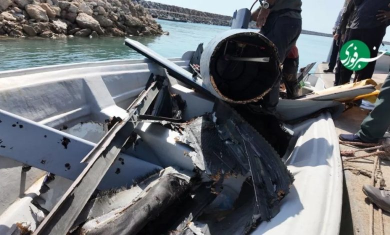
Iranian air defense systems shot down a reconnaissance drone described only as belonging to “the enemy” overnight between 5 and 6 May 2026, according to the semi-official Fars News Agency. The intercept was claimed to have occurred over the Strait of Hormuz near Qeshm Island, placing the engagement at approximately grid reference 40RCQ 95609 61391 (26.770°N, 55.950°E), within the IRGC-declared control area over the western strait. Fars published imagery it said showed the downed UAV, though those images have not been independently verified by Western OSINT sources at time of publication.
No party has claimed ownership of the drone. The United States Central Command, which operates the active naval escort mission in the strait known as Project Freedom, had not issued a public response at time of publication. The IRGC’s deliberate use of the term “enemy” without specifying a national origin is a consistent pattern in Iranian military communications during the current conflict: it preserves operational ambiguity while signalling air defense activity to a domestic audience.
The claim arrives on day 67 of the Hormuz crisis and approximately 28 days into a fragile ceasefire that has been under mounting pressure since the United States launched its Project Freedom convoy escort operation on 4 May 2026. Iran responded to that operation with drone and ballistic missile attacks on the UAE, including a strike on an oil facility at Fujairah. The overnight drone intercept, if verified, would mark an additional layer of activity in the airspace above the world’s most contested maritime chokepoint.

A bulk cargo ship anchored in the Strait of Hormuz off Bandar Abbas, 2 May 2026, as the IRGC maintains its declared closure of the waterway. Photo: Amirhosein Khorgooi / AP / ISNA.
🔴 Verification Status
A Single Source, Unverified Images and a Deliberate Gap in Attribution
⚠ SINGLE-SOURCE This report originates from a single source: the Fars News Agency Telegram channel (farsna/433912). Fars is a semi-official Iranian state outlet with institutional links to several branches of the Iranian military. Its reporting on kinetic events inside Iranian-controlled airspace and waters is treated as primary sourcing for Iranian state claims, but those claims require corroboration before they can be treated as established fact. No wire agency, including Reuters, AFP or AP, had independently confirmed this intercept at time of publication.
The imagery published by Fars alongside the claim has not been cross-checked against reverse image search or geolocation tools. Drone wreckage images are a frequently recycled element of Iranian information operations: photos from previous intercepts or unrelated events have appeared before in such announcements. Strategy Battles is treating the Fars images as unverified until independent geolocation or wire agency confirmation is available.
LiveUAMap geolocated the Fars report to Hormozgan Province, placing the intercept broadly consistent with the western Qeshm Island airspace. That geolocation is drawn from the Fars text, not from independent satellite or radar data. The absence of a named operator for the drone is notable: in previous intercept claims during this conflict, Iranian sources have named Israeli or American UAVs when the political value of the attribution favoured doing so. The choice to use “enemy” instead suggests either genuine uncertainty about origin or a deliberate decision to avoid an attribution that could escalate or complicate ongoing ceasefire negotiations.
⚠ Fars News Agency / Telegram farsna/433912, 6 May 2026 (single-source, translated)
“The reconnaissance drone belonging to the enemy was shot down by the country’s air defense [systems] in the Strait of Hormuz area.”
🔵 Operational Context
Project Freedom, Escalating UAV Activity and the Ceasefire’s Air Dimension
The Strait of Hormuz has become one of the most intensively surveilled maritime corridors on the planet since Iran declared its closure on 28 February 2026. Both the United States and its partners, and Iran, operate persistent intelligence, surveillance and reconnaissance assets over the waterway. The IRGC maintains declared military control over a wide zone spanning from the western tip of Qeshm Island to the UAE’s Umm al Quwain emirate in the west and from Iran’s Mount Mobarak to Fujairah in the east, a boundary published by Fars earlier this week. Any drone operating inside that zone without IRGC clearance will be treated as hostile under Iran’s stated rules of engagement.
The United States operates several reconnaissance drone types in the region with a long history of Hormuz patrols, including the MQ-4C Triton maritime surveillance platform and smaller tactical UAVs deployed from carrier strike groups. Israel likewise operates long-range ISR drones capable of reaching the Gulf. Gulf Arab states, including the UAE and Saudi Arabia, have their own ISR assets. The identification of this particular shoot-down as any one of those platforms remains unconfirmed.
On 4 May, President Trump launched Project Freedom, the US military convoy escort operation to guide vessels through the strait. Iran responded the same day with drone and missile attacks on the UAE, including the Fujairah oil facility. The ceasefire, extended from its original 22 April end date, is now under its most severe stress since it came into effect on 8 April. The drone intercept claim sits within a broader pattern: Iran is signalling in every available domain, naval, aerial and informational, that it retains both the will and the capability to contest access to the strait.
🟢 What Iran’s Air Defense Activity Signals
Persistent ISR Suppression as a Strategic Instrument
Even if this specific intercept cannot be independently verified, the pattern it represents is analytically significant. Iran has a documented record of shooting down or attempting to shoot down reconnaissance drones in the Gulf: the 2019 destruction of a US Navy RQ-4A Global Hawk over the strait was perhaps the most prominent example before the current conflict. In the present war, Iranian air defense engagement of drones has been reported in the vicinity of Tehran, over the Persian Gulf and now, per this claim, in the strait itself. The geographic spread is consistent with an IRGC strategy of denying ISR access across all domains, not only over the Iranian mainland.
Suppressing reconnaissance assets over the strait serves Iranian operational objectives in at least two ways. First, it limits the ability of the US Navy and its partners to build a real-time picture of IRGC mine-laying activity, fast-boat movements and surface-to-air missile repositioning around the chokepoint. Second, every claimed shoot-down, whether verified or not, has informational value: it signals to commercial shipping operators and their insurers that the airspace above the strait is contested, compounding the risk calculation that already keeps tanker traffic at roughly two percent of its pre-war baseline.
The timing is worth noting. The intercept claim emerged the day after US destroyers reportedly crossed the strait and entered the Arabian Gulf, and on the same day that a US Navy F/A-18 Super Hornet fired on an Iranian-flagged vessel attempting to breach the naval blockade. Iran’s air defense announcement may be a calibrated contribution to what analysts tracking the crisis have called a “micro-escalation” cycle: a sequence of actions by both sides that test the ceasefire boundaries without crossing into the kind of direct military exchange that would collapse the negotiating framework entirely. Whether this particular intercept is genuine, exaggerated or fabricated, its release into the information environment serves that signalling function regardless.
Strategy Battles Assessment
The Drone Intercept as Information Operation: Iran Does Not Need This to Be True to Make It Useful
The most important thing to understand about this report is that its strategic value to Iran is largely independent of whether it is accurate. A verified shoot-down would demonstrate that IRGC air defense systems are operational, alert and effective in the strait’s airspace at a moment when Iran needs to project defensive capability amid ceasefire strain. An unverified or fabricated shoot-down achieves roughly the same informational objective, provided it is not promptly contradicted by the opposing side. The absence of any US or Israeli denial in the hours following the Fars publication is not confirmation, but it is a gap that Iran’s information apparatus will exploit.
The identity question is also deliberate. By describing the UAV as belonging to “the enemy” rather than attributing it to the United States, Israel or a Gulf Arab state, Iran has preserved its options. Naming the US would create a direct escalation anchor at a moment when both Washington and Tehran are, according to multiple reports, within reach of a one-page memorandum to end the war. Naming Israel would invite a different kind of pressure. The vague attribution keeps the claim in the news cycle while minimising the diplomatic cost of making it.
Strategy Battles assesses this as a low-confidence single-source claim with high informational intent. Until wire agency corroboration or CENTCOM comment is available, the intercept should be treated as an unverified Iranian state claim, noted as part of a documented pattern of ISR-suppression signalling, and watched for subsequent imagery or radar data that might confirm or contradict it. The broader pattern it reflects, persistent Iranian air defense alertness in the strait’s airspace during ceasefire talks, is analytically established and strategically significant regardless of this specific claim’s accuracy.
Strategy Battles Related Coverage
Sources:
- Fars News Agency Telegram (farsna/433912) – Primary source, drone intercept claim, 6 May 2026
- LiveUAMap – Iran: IRGC air defense drone intercept near Qeshm Island, 6 May 2026
- Wikipedia – 2026 Strait of Hormuz crisis (ongoing timeline)
- CNN – US and Iranian militaries trade shots as Hormuz tensions escalate, 4-5 May 2026
- NPR / AP – US tries to force open Strait of Hormuz as UAE comes under attack, 4 May 2026
- Iran SITREP – Day 67 Hormuz Restricted Analysis, 5 May 2026
Editorial Verification
Drone intercept claim: single-source, Fars News Agency Telegram (farsna/433912). Not corroborated by any wire agency (Reuters, AFP, AP) at time of publication. Explicitly flagged throughout article with purple single-source tags. LiveUAMap geolocation of the Fars report provides supporting geographic context but draws on the same primary source and does not constitute independent corroboration. Drone imagery published by Fars: unverified, not cross-checked via reverse image search or InVID at time of publication. US Central Command (CENTCOM) had not issued a public response at time of publication. No denial was located after searching. Broader contextual reporting on Project Freedom, IRGC control zone and ceasefire status corroborated by CNN, NPR/AP, Wikipedia (2026 Strait of Hormuz crisis) and IranSitrep, all sourced independently.
MGRS datum: WGS84 / UTM Zone: 40R / Cross-check reference: Bandar Abbas 40RDR 27352 06939 (27.183N, 56.267E), approximately 45 km northeast of Qeshm Island.
All claims independently attributed and verified to open sources where possible.
Approved for Publication
Marcus V. Thorne
Lead Editor, Strategy Battles
©StrategyBattles.net 2026
This article is for news and analysis purposes only. Based on publicly available news sources and military updates. All rights reserved. Not for commercial reuse without permission.