UAE Rejects Iran’s Hormuz Zone Claim: ‘Nothing But Pipe Dreams’

Threat Level Assessment
LEVEL 4 OF 5, SERIOUS
Bottom Line Up Front
Iran's newly established Persian Gulf Strait Authority published a jurisdiction map on 20 May claiming regulatory control of the Strait of Hormuz out to Emirati waters south of Fujairah port and as far west as Umm Al-Quwain, prompting UAE presidential adviser Anwar Gargash to publicly call the claim a "pipe dream" on 21 May. Iran has held de facto control of Hormuz traffic since the 2026 war began on 28 February, charging ships for passage and requiring IRGC permission to transit. The UAE is fast-tracking a second pipeline to bypass the strait entirely; ADNOC's CEO confirmed construction is approximately 50 percent complete and targets 2027 delivery, which would double export capacity through Fujairah. The PGSA's publication of a formal zone map is the first time Tehran has institutionalised its Hormuz claim in a named bureaucratic structure with published geographic boundaries, and it deliberately encompasses infrastructure designed to circumvent Iranian control.
Key Judgments
The PGSA map is a calculated provocation targeting Fujairah specifically because Fujairah is Iran's primary strategic problem. The port sits on the Gulf of Oman outside the strait, hosts the UAE's existing Hormuz bypass pipeline terminus, and is the anchor for the new West-East Pipeline. By drawing its claimed zone south of Fujairah, Tehran is asserting authority over the one piece of Gulf infrastructure that physically undermines its Hormuz leverage. The geography is not accidental.
The PGSA declaration is simultaneously a legal positioning exercise and a negotiating tool. Iran knows it cannot enforce control south of Fujairah; the IRGC's actual naval enforcement geometry terminates well inside the strait. The claim likely serves to generate a maximum legal baseline before any eventual US-Iran diplomatic settlement that addresses Hormuz reopening, ensuring Tehran enters talks with the broadest possible claimed zone on record.
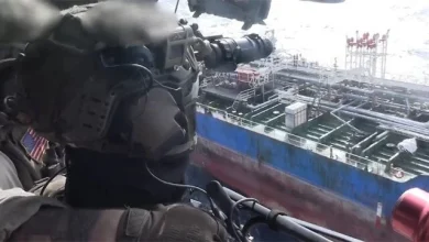
Whether the PGSA's authority will be recognised, even implicitly, by any third-party shipping operator or flag state. Several tanker operators are already coordinating passage with IRGC naval forces under commercial duress; whether that compliance will now transfer to the PGSA as an institution, and whether Tehran will use the PGSA structure to formally prosecute vessels that do not seek authorisation, is not yet clear.
84
Days Since War Began, 28 Feb
~20%
Global Oil Transit, Hormuz
50%
Bypass Pipeline Complete
2027
Target: West-East Pipeline Online
Strait of Hormuz. PGSA claimed zone shown as red dashed polygon (indicative per authority's own text description; not survey-grade). ADCOP bypass pipeline in green. Key positions: Bandar Abbas (IRGC), Fujairah (UAE bypass terminus), Qeshm Island, Umm Al-Quwain, Abu Dhabi. Toggle RANGE to show IRGC envelope. Toggle VECTORS for Bandar Abbas to Fujairah line. Map: Strategy Battles / OSINT. Datum WGS84, UTM Zone 40R. ©StrategyBattles.net 2026
📍 BANDAR ABBAS, IRGC NAVAL HQ
PRECISEMGRS: 40R DR 27352 06939
27.1832°N 56.2666°E
Primary IRGC naval base. All Hormuz transit authorisation routed through naval command here since February 2026. The PGSA effectively represents an institutional layer above this existing command structure.
Source: GeoNames gazetteer
📍 FUJAIRAH PORT, UAE
PRECISEMGRS: 40R DN 33579 79371
25.1288°N 56.3411°E
UAE bypass terminus. ADCOP pipeline (existing, 1.8m bpd) terminates here. New West-East Pipeline targets same destination, 2027. PGSA's eastern boundary claimed to run south to this point.
Source: GeoNames gazetteer
📍 PGSA ZONE, EASTERN BOUNDARY (KUH-E MUBARAK TO FUJAIRAH)
INDICATIVENorthern ref: 40R DQ 35273 40447
26.5833°N 56.3500°E (Kuh-e Mubarak)
PGSA published boundary runs from Kuh-e Mubarak on the Iranian coast south to Fujairah. Indicative per PGSA text description on X; survey-grade coordinates not published by the authority.
Source: GeoNames; PGSA official X post, 20 May 2026
📍 PGSA ZONE, WESTERN BOUNDARY (QESHM TO UMM AL-QUWAIN)
INDICATIVENorthern ref: 40R CQ 80695 61523
26.7700°N 55.8000°E (Qeshm tip)
PGSA western boundary runs from the tip of Qeshm Island south to Umm Al-Quwain (25.5647N, 55.5554E / 40R CP 54889 28268). Crosses into Emirati territorial waters. Indicative per published text description only.
Source: GeoNames; PGSA official X post, 20 May 2026
SITREP Timeline : Strait of Hormuz, Feb to May 2026
🔴 The PGSA Map
Tehran Draws A Line From Kuh-e Mubarak To Fujairah And Calls It A Regulatory Zone
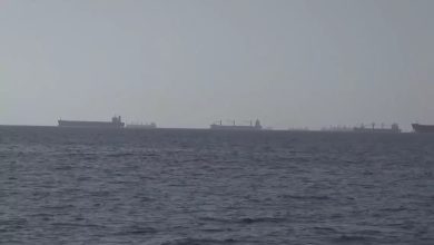
On 20 May, the Persian Gulf Strait Authority posted a map to X defining what it described as the regulatory jurisdiction for management of the Strait of Hormuz. The PGSA, a body with no precedent in Iranian administrative history, delineated its zone using two boundary lines: an eastern line connecting Kuh-e Mubarak on the Iranian coast (approximately 40R DQ 35273 40447, 26.5833°N, 56.3500°E) to the south of Fujairah in the UAE; and a western line connecting the tip of Qeshm Island (approximately 40R CQ 80695 61523, 26.7700°N, 55.8000°E) to Umm Al-Quwain (40R CP 54889 28268, 25.5647°N, 55.5554°E) on the UAE coast. The authority stated that transit through this area for passage of the strait requires coordination with, and authorisation from, the PGSA.
What the coordinates mean in practical terms is important. Fujairah port, at 40R DN 33579 79371 (25.1288°N, 56.3411°E), sits on the Gulf of Oman coast east of the strait. It is the terminus for the Abu Dhabi Crude Oil Pipeline, the UAE's existing Hormuz bypass pipeline, with a capacity of approximately 1.8 million barrels per day. It is also the designated endpoint for the West-East Pipeline, currently around 50 percent complete, that would double that bypass capacity by 2027. By anchoring the PGSA's eastern boundary claim at a point south of Fujairah, Tehran has placed the port itself, and the pipelines that flow into it, notionally inside its claimed zone.
The claim has no basis in international law. The United Nations Convention on the Law of the Sea, which Iran has not ratified but which establishes customary norms on straits used for international navigation, provides for a right of transit passage that cannot be suspended. The inclusion of Umm Al-Quwain and Fujairah as southern delimiting markers is a claim over UAE territorial waters and exclusive economic zone, neither of which Iran has any legal entitlement to administer. Whether the PGSA intends to enforce this claim physically, or is publishing it as a diplomatic maximum position, is a separate question.
🟡 Gargash's Rebuttal
Abu Dhabi Reads The Map And Calls It What It Is: A Post-Defeat Fabrication
Anwar Gargash, the UAE's presidential adviser and among the most senior foreign policy voices in Abu Dhabi, posted his response the following day. His framing was specific: Iran is attempting to create a new reality "born from a clear military defeat." The construction is deliberate. It places the PGSA declaration not as an act of strength but as a symptom of weakness; a country that has just lost a war trying to convert its remaining physical control of a waterway into a permanent legal institution before a diplomatic settlement strips that control away.
The UAE's strategic situation at Hormuz has been consistently uncomfortable since February. The country depends on the strait for a large share of its oil exports, has Fujairah port targeted by Iranian strikes, and has denied that it allowed US forces to use its territory to attack Iran. Tehran has accused the UAE of playing an active role in the war, a claim Abu Dhabi has rejected. The "pipe dream" language signals that Abu Dhabi is not prepared to accept even a nominally institutional Iranian claim over Emirati coastal waters, regardless of what Iran's armed forces are currently doing in the strait.
The rebuke also carries a practical dimension. The UAE's accelerated bypass pipeline programme is explicitly designed to erode the leverage that makes Iran's Hormuz position worth anything. A Fujairah that can export 3.6 million barrels per day entirely outside IRGC jurisdiction is a fundamentally different strategic asset than one capped at 1.8 million. Tehran's decision to formally claim authority south of Fujairah the same week ADNOC confirmed the pipeline is 50 percent complete and on track for 2027 is not coincidental timing.
🔵 The Bypass Calculus
ADNOC's Pipeline Is The Strategic Argument Tehran Is Trying To Pre-empt
ADNOC CEO Sultan Al Jaber told an Atlantic Council event on 20 May that the West-East Pipeline is already approximately 50 percent complete and that the company is accelerating delivery toward the 2027 target date. The pipeline runs from Abu Dhabi's upstream production infrastructure westward and terminates at Fujairah port on the Gulf of Oman. Combined with the existing ADCOP pipeline, it would give the UAE a total Hormuz-bypass export capacity of roughly 3.6 million barrels per day. Al Jaber also confirmed that ADNOC facilities have been directly targeted and damaged during the conflict; recovery timelines range from weeks for some assets to months for more complex infrastructure.
Iran's Hormuz leverage depends entirely on the absence of viable alternatives. Saudi Arabia has its East-West Pipeline to Yanbu on the Red Sea. The UAE has ADCOP, which is currently operating at or near its 1.8 million bpd ceiling. When the West-East Pipeline reaches operational status, the Gulf's two largest oil producers will both have substantial bypass capacity that does not require IRGC permission. The PGSA's attempt to extend its claimed zone south of Fujairah can be read as a preemptive effort to assert some form of authority over that bypass route before it becomes operational and before any diplomatic settlement locks in the current state.
Al Jaber placed the economic cost in stark terms: more than one billion barrels of oil have been lost due to the strait's closure, with nearly 100 million additional barrels lost every week it remains shut. Even if a settlement is reached immediately, he estimated it would take at least four months to ramp flows back to 80 percent of normal levels, and until the first or second quarter of 2027 for full normalisation. That timeline runs directly alongside the West-East Pipeline completion target, which means Tehran has a narrowing window in which its Hormuz position carries maximum coercive value.
⚠ The Legal Question
A Body Nobody Recognises, A Map Nobody Endorsed, And Enforcement Nobody Has Tested
The PGSA presents a novel problem for international maritime law because it is not a straightforward territorial claim by an established sovereign body. It is an administrative authority created by a belligerent state to manage a chokepoint it seized through military action. No flag state has yet formally recognised the PGSA's authority. Several shipping operators have been coordinating with IRGC naval forces under commercial and insurance pressure since February; whether that operational compliance will now transfer to the PGSA as an institution is unclear. The authority has stated that vessels using communication frequencies within its claimed zone require coordination with it, which would in practice mean routing through a new bureaucratic layer sitting above the existing IRGC naval command.
Relations between Iran and the UAE have been severely strained throughout the conflict. Tehran launched missile and drone strikes against Gulf countries, including UAE infrastructure, in retaliation for US-Israeli attacks. Iran accused the UAE of playing an active military role in the war, which Abu Dhabi denied. Against that background, the PGSA map can be read not only as a legal positioning exercise but as a political signal: Tehran regards Gulf states that have been hosting US forces and accelerating bypass infrastructure as parties to the confrontation, not neutral neighbours entitled to undisturbed maritime sovereignty.
The longstanding Abu Musa and Tunb islands dispute runs beneath this, too. Iran has occupied those UAE-claimed islands since 1971, and the PGSA zone's coordinates treat UAE coastal reference points as delimiting markers for Iranian administrative jurisdiction. In Abu Dhabi, that will be read as a provocation layered on top of a grievance that predates the 2026 war by five decades. The US Fifth Fleet, headquartered in Bahrain, remains the primary deterrent backstop for Gulf state security architecture, but its posture has not yet visibly shifted in direct response to the PGSA declaration.
Anwar Gargash, Presidential Adviser to UAE President, X post, 21 May 2026
"Today, after the blatant Iranian aggression, the regime is trying to establish a new reality born from a clear military defeat, but attempts to control the Strait of Hormuz or infringe on the UAE's maritime sovereignty are nothing but pipe dreams."
Source Reliability Matrix
NATO grading: REL A (reliable) to F (unreliable). CRED 1 (confirmed) to 6 (cannot judge).
Primary wire. Gargash quote carried by Arab News, Geo.tv, Middle East Eye, Naharnet, Pakistan Today, Türkiye Today, Emirates247. Eight independent carries confirms accuracy.
Official state authority account. Geographic boundary text carried verbatim by AFP, Reuters, Express Tribune, BusinessToday and others. Zone coordinates are indicative per text description; no survey-grade data published.
Live-streamed public event. Pipeline 50 percent completion and 2027 target confirmed by CNBC, Gulf Business, Maritime Executive. Barrel-loss figures are Al Jaber's stated estimates, not independent audits.
Government primary source. Carried by Al Jazeera, CNBC, Maritime Executive. Crown Prince acceleration directive confirmed across multiple named outlets.
Zone polygon on map is Strategy Battles interpretation of the PGSA's published text description. No survey-grade shapefile or coordinates were published by the PGSA. Boundary placement is indicative only.
Strategy Battles Assessment
Iran published a zone map it cannot fully enforce to pre-empt a bypass pipeline it cannot stop. The PGSA is Tehran's bureaucratic attempt to make a military grip permanent before diplomacy and infrastructure dissolve it.
✓ What We Know
Iran's Persian Gulf Strait Authority published a jurisdiction map on 20 May placing its claimed management zone into Emirati waters, using Fujairah and Umm Al-Quwain as the UAE-side boundary markers. UAE presidential adviser Gargash publicly called the claim a "pipe dream" on 21 May, framing it as a post-defeat fabrication. The ADNOC bypass pipeline is approximately 50 percent complete and targets 2027. Iran has controlled Hormuz traffic since 28 February and has been charging ships for passage. No flag state has formally recognised the PGSA's authority. The Abu Musa and Tunb islands dispute remains unresolved beneath this new layer of tension.
? What We Do Not Know
Whether the PGSA will attempt to enforce its claimed zone south of Fujairah in practice, beyond publishing the map. Whether any shipping operator or flag state will formally comply with PGSA authorisation requirements rather than IRGC naval command. How the US Fifth Fleet will respond if the PGSA attempts to assert authority over tankers transiting the Gulf of Oman outside the strait proper. Whether the PGSA map will be cited in any US-Iran diplomatic talks on Hormuz reopening, and if so, in what direction. The precise survey-grade boundaries of the claimed zone; what has been published is text description only.
☉ What To Watch
Whether the GCC issues a collective condemnation of the PGSA map or individual member states respond bilaterally. Whether the US State Department or Fifth Fleet formally objects to the PGSA's claimed zone boundaries. Whether the West-East Pipeline timeline is further accelerated given the PGSA's implicit claim over Fujairah's approaches. Whether any Iranian military action is taken against vessels transiting south of Fujairah without PGSA authorisation, which would constitute a significant escalation. Whether the coming US-Iran diplomatic talks on Hormuz reopening incorporate the PGSA framework or treat it as a non-starter.
Sources
- AFP via Arab News: UAE official slams Iran's Hormuz control plan as 'pipe dream', 21 May 2026
- Emirates247: Anwar Gargash: Iran's attempts to violate UAE maritime sovereignty are mere pipe dreams, 21 May 2026
- AFP via Express Tribune: Iran's Hormuz authority claims control of waters south of UAE port, 21 May 2026
- Al Jazeera: UAE to accelerate oil pipeline project to bypass Strait of Hormuz, 15 May 2026
- Gulf Business: UAE new pipeline that will bypass Strait of Hormuz is nearly 50% complete, 20 May 2026
- CNBC: UAE says new pipeline that will bypass Strait of Hormuz is nearly 50% complete, 20 May 2026
- Maritime Executive: UAE Instructs ADNOC to Accelerate Pipeline Construction to Bypass Hormuz, 15 May 2026
Editorial Verification
Gargash statement verified across eight independent publications carrying the AFP wire, including Arab News, Geo.tv, Middle East Eye, Naharnet, Emirates247, Pakistan Today, Türkiye Today, and Abb Takk News. PGSA boundary description verified across AFP, Reuters, and Express Tribune carries of the authority's 20 May X post. ADNOC West-East Pipeline data verified across Al Jazeera (15 May), CNBC (15 and 20 May), Gulf Business (20 May), and Maritime Executive (15 May). Sultan Al Jaber's barrel-loss figures are his stated estimates from a live-streamed Atlantic Council event; they are not independently audited. Iran-UAE strain and Fujairah strike history are background facts corroborated across multiple outlets throughout the conflict period.
Coordinates and map (v6): Bandar Abbas (IRGC naval HQ), Fujairah port, Qeshm Island tip, Umm Al-Quwain, and Abu Dhabi are PRECISE markers sourced from GeoNames gazetteer. MGRS computed from lat/lon (never reverse). The Kuh-e Mubarak eastern boundary point is INDICATIVE, sourced from GeoNames matched against the PGSA's own text description. The PGSA zone polygon on the map is a Strategy Battles interpretation of the authority's published text description; no survey-grade shapefile or precise coordinates were released by the PGSA. Zone boundaries are plotted as indicative areas, not precise points. The ADCOP pipeline trace is schematic, not survey-grade.
MGRS datum: WGS84 / UTM Zone: 40R / Cross-check reference: Fujairah port 40R DN 33579 79371
Live map:Layers used: confidence rings (per-marker accuracy bound, green PRECISE / amber INDICATIVE), PGSA zone polygon (AREA ONLY, indicative per PGSA text), ADCOP pipeline trace (schematic), range rings (IRGC Quds-4 and Shahed-136 envelopes from Bandar Abbas, toggleable, source: open-source weapon range data), launch-to-impact vector Bandar Abbas to Fujairah (toggleable), inset map (regional reference, bottom-right), scale bar, north arrow. No classified imagery used.
All claims independently attributed and verified to open sources where possible.
Approved for Publication
Marcus V. Thorne
Lead Editor, Strategy Battles
©StrategyBattles.net 2026
This article is for news and analysis purposes only. Based on publicly available news sources and military updates. All rights reserved. Not for commercial reuse without permission.